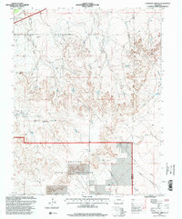
1996 Map of Thompson Arroyo
USGS Topo · Published 2000About this map
Comanche National Grassland dominates the southern portion of this landscape, reflecting a region defined by conservation and grazing near the border of Otero and Bent counties. The terrain is deeply incised by drainage networks, most notably Thompson Arroyo and the East Fork King Arroyo, which carve through the high plains toward Miller Mesa. Water management is central to this arid environment, evidenced by the presence of the Vandiver Canal, various isolated wells, and the Circle T Waters Spring. Near the northern edge, a solitary Drive-in Theater and a Gravel Pit suggest localized commercial and industrial activity along the road network. These features, alongside the prominent Communication Tower, represent the modernization of a remote prairie landscape during the late twentieth century.
Find a feature on this map
16 named features on this map. Tap any name to fly to it.
Don’t see what you’re looking for? This feature index may not catch every label — zoom into the map to look around manually.
Map Details
Editions of this 1996 Thompson Arroyo Map
This is the sole edition of this map. No revisions or reprints were ever made.
Other maps of this area

1891 · Catlin
USGS Topo · 1:125,000

1891 · Higbee
USGS Topo · 1:125,000

1891 · Las Animas
USGS Topo · 1:125,000

1891 · Timpas
USGS Topo · 1:125,000

1893 · Higbee
USGS Topo · 1:125,000

1893 · Las Animas
USGS Topo · 1:125,000

1893 · Catlin
USGS Topo · 1:125,000

1894 · Timpas
USGS Topo · 1:125,000

1953 · Cheraw
USGS Topo · 1:24,000

1953 · Cornelia
USGS Topo · 1:24,000