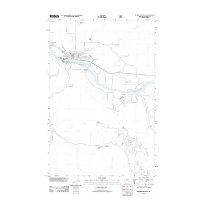
2011 Map of Thompson Falls
USGS Topo · Published 2011About this map
Thompson Falls sits as the primary hub along the Clark Fork, where the river’s power is harnessed by the Thompson Falls Dam. The town layout in this early 21st-century record shows a concentration of civic and social life, evidenced by the Thompson Falls Post Office and multiple fire stations. To the east, three distinct burial grounds—Wild Rose Cemetery, VFW Cemetery, and Fraternal Cemetery—provide a localized genealogical record. The river remains the central geographic feature, widening into the Thompson Falls Reservoir and hosting unique transportation infrastructure like the Daves Landing Seaplane Base and the Main Channel Bridge. South of the river, the terrain rises toward Clark Mountain and Elk Point, where the landscape transitions from the river-level community to the more remote Gold Rush Gulch and its associated Gold Rush Campground. Near the eastern bend, the settlement of Woodlin and the Thompson Falls Airport reflect the area’s continued development.
Find a feature on this map
78 named features on this map. Tap any name to fly to it.
Don’t see what you’re looking for? This feature index may not catch every label — zoom into the map to look around manually.
Map Details
Editions of this 2011 Thompson Falls Map
This is the sole edition of this map. No revisions or reprints were ever made.
Other maps of this area

1918 · St Regis
USGS Topo · 1:125,000

1919 · St. Regis
USGS Topo · 1:125,000

1937 · Thompson Falls
USGS Topo · 1:125,000

1937 · Thompson Falls
USGS Topo · 1:62,500

1956 · St Regis
USGS Topo · 1:62,500

1956 · Wallace
USGS Topo · 1:250,000

1957 · Thompson Falls
USGS Topo · 1:62,500

1957 · Haugan
USGS Topo · 1:62,500

1960 · Wallace
USGS Topo · 1:250,000

1964 · Eddy Mountain
USGS Topo · 1:24,000