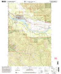
1999 Map of Thompson Falls
USGS Topo · Published 2003About this map
Thompson Falls serves as the hub of activity in this mountain valley where the Clark Fork is harnessed by the Thompson Falls Dam. The town's institutional infrastructure is well-defined, showing both a High Sch and Jr High Sch, a local Cem, and the Thompson Falls Work Center. Transportation and utility networks are central to the landscape, with the Thompson Falls Airport situated on a flat bench above the river, while a Power Plant and Substation stand near the Noxon Res shoreline.
Find a feature on this map
32 named features on this map. Tap any name to fly to it.
Don’t see what you’re looking for? This feature index may not catch every label — zoom into the map to look around manually.
Map Details
Editions of this 1999 Thompson Falls Map
This is the sole edition of this map. No revisions or reprints were ever made.
Other maps of this area

1918 · St Regis
USGS Topo · 1:125,000

1919 · St. Regis
USGS Topo · 1:125,000

1937 · Thompson Falls
USGS Topo · 1:125,000

1937 · Thompson Falls
USGS Topo · 1:62,500

1956 · St Regis
USGS Topo · 1:62,500

1956 · Wallace
USGS Topo · 1:250,000

1957 · Thompson Falls
USGS Topo · 1:62,500

1957 · Haugan
USGS Topo · 1:62,500

1960 · Wallace
USGS Topo · 1:250,000

1964 · Eddy Mountain
USGS Topo · 1:24,000