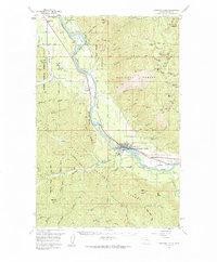
1957 Map of Thompson Falls
USGS Topo · Published 1984About this map
Thompson Falls serves as the focal point of this mid-century survey, situated along the banks of The Clark Fork. The community’s infrastructure is clearly defined, including the VFW Cem, a central Powerhouse, and an Airstrip to the east. The industrial and transportation corridor follows the river valley, where the Northern Pacific railroad tracks connect the main town with the smaller settlements of Belknap and White Pine.
Find a feature on this map
76 named features on this map. Tap any name to fly to it.
Don’t see what you’re looking for? This feature index may not catch every label — zoom into the map to look around manually.
Map Details
Editions of this 1957 Thompson Falls Map
3 editions found

Other maps of this area

1914 · Avery
USGS Topo · 1:125,000

1917 · Avery
USGS Topo · 1:125,000

1918 · St Regis
USGS Topo · 1:125,000

1919 · St. Regis
USGS Topo · 1:125,000

1932 · Trout Creek
USGS Topo · 1:125,000

1935 · Trout Creek
USGS Topo · 1:125,000

1936 · Trout Creek
USGS Topo · 1:125,000

1937 · Thompson Falls
USGS Topo · 1:125,000

1937 · Thompson Falls
USGS Topo · 1:62,500

1956 · Cooper Gulch
USGS Topo · 1:62,500