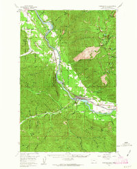
1957 Map of Thompson Falls
USGS Topo · Published 1963About this map
Thompson Falls serves as the hub of this mid-century landscape, situated along the Northern Pacific railroad and the Clark Fork river. The map records the area just before a significant topographical change: blue hachured lines indicate the extent of the proposed Noxon Rapids Reservoir, which was planned to alter the river valley near Finley Flats and Belknap. Outside the river corridor, the terrain is defined by the steep ridges of the Kaniksu National Forest and Lolo National Forest. Local industry and infrastructure are evident in features such as the Lucky Luke Mine, a Sawmill near the town center, and the Airstrip to the east. High-elevation landmarks like Cube Iron Mtn and Mt Silcox overlook numerous glacial lakes, including Graves Lake and Arrowhead Lake, while the VFW Cem provides a point of interest for genealogists researching family history in White Pine.
Find a feature on this map
68 named features on this map. Tap any name to fly to it.
Don’t see what you’re looking for? This feature index may not catch every label — zoom into the map to look around manually.
Map Details
Editions of this 1957 Thompson Falls Map
3 editions found

Other maps of this area

1914 · Avery
USGS Topo · 1:125,000

1917 · Avery
USGS Topo · 1:125,000

1918 · St Regis
USGS Topo · 1:125,000

1919 · St. Regis
USGS Topo · 1:125,000

1932 · Trout Creek
USGS Topo · 1:125,000

1935 · Trout Creek
USGS Topo · 1:125,000

1936 · Trout Creek
USGS Topo · 1:125,000

1937 · Thompson Falls
USGS Topo · 1:125,000

1937 · Thompson Falls
USGS Topo · 1:62,500

1956 · Cooper Gulch
USGS Topo · 1:62,500