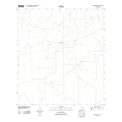
2010 Map of Thompsonville
USGS Topo · Published 2010About this map
Thompsonville serves as the central point of reference in this South Texas landscape, situated at the intersection of several ranching routes in Zapata County. The terrain is defined by the winding course of Arroyo Grande, which meanders across the brush country toward the southern boundary where it nears Los Tanques Creek. The map reveals a network of roads reflecting the area's agricultural and ranching heritage, including La Pita Ranch Rd and Casa Blanca Ranch Rd.
Find a feature on this map
11 named features on this map. Tap any name to fly to it.
Don’t see what you’re looking for? This feature index may not catch every label — zoom into the map to look around manually.
Map Details
Editions of this 2010 Thompsonville Map
This is the sole edition of this map. No revisions or reprints were ever made.
Other maps of this area

1939 · Bruni
USGS Topo · 1:62,500

1939 · Randado
USGS Topo · 1:62,500

1940 · Aguilares
USGS Topo · 1:62,500

1940 · Randado
USGS Topo · 1:62,500

1940 · Mogotes Hill
USGS Topo · 1:62,500

1956 · Mogotes Hill
USGS Topo · 1:62,500

1956 · Laredo
USGS Topo · 1:250,000

1972 · Armstrong Ranch
USGS Topo · 1:24,000
1972 · San Pablo Ranch
USGS Topo · 1:24,000

1972 · Albercas Ranch
USGS Topo · 1:24,000