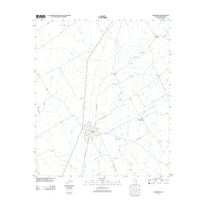
2013 Map of Thornton
USGS Topo · Published 2013About this map
Thornton serves as the central hub of this Limestone County landscape, where a grid of streets including Hill St, Ellis St, and Bowie St meets the intersection of FM-1246 and Farm-to-Market Road 723. The surrounding rural territory is defined by a dense network of watercourses, most notably Steele Creek, Cedar Creek, and Davis Creek. Scattered throughout the countryside are several small named settlements such as Beulah, Red Hill, and Davis Prairie, suggesting a long-established pattern of community centers linked by county roads. Local family and community history is anchored by numerous burial grounds, including the Tidwell Cem and Cobb Cem. The terrain is also marked by distinct landmarks like Twin Bridges over Montgomery Creek, illustrating how local infrastructure adapts to the area's intricate drainage system of branches and creeks.
Find a feature on this map
90 named features on this map. Tap any name to fly to it.
Don’t see what you’re looking for? This feature index may not catch every label — zoom into the map to look around manually.
Map Details
Editions of this 2013 Thornton Map
This is the sole edition of this map. No revisions or reprints were ever made.
Other maps of this area

1920 · Mexia
USGS Topo · 1:62,500

1954 · Waco
USGS Topo · 1:250,000

1955 · Waco
USGS Topo · 1:250,000

1957 · Groesbeck
USGS Topo · 1:62,500

1960 · Groesbeck
USGS Topo · 1:24,000

1965 · Kosse West
USGS Topo · 1:24,000

1966 · Thornton
USGS Topo · 1:24,000
1966 · Box Church
USGS Topo · 1:24,000
1966 · Fallon
USGS Topo · 1:24,000
1966 · Ben Hur
USGS Topo · 1:24,000