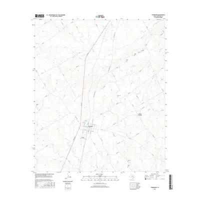
2016 Map of Thornton
USGS Topo · Published 2016About this map
Thornton serves as the central hub of this Limestone County landscape, where the local street grid intersects with the Railroad and several farm-to-market roads. The town's layout, featuring named streets like S Ellis St and S Preston St, is surrounded by a dense network of family-named cemeteries and watercourses that reflect generations of local settlement. To the east, Davis Prairie marks a distinctive open geographic area, while the terrain is dissected by numerous creek branches, including Steele Cr, Cedar Cr, and Phifer Cr. Genealogists will find a wealth of burial sites scattered across the countryside, from Pleasant Grove Cem near the town center to more remote locations like Tidwell Cem and Vinson Cem in the southern reaches. The abundance of small drainages like Eaton Br and Acuff Br feeding into larger systems illustrates the well-watered nature of this agricultural region.
Find a feature on this map
82 named features on this map. Tap any name to fly to it.
Don’t see what you’re looking for? This feature index may not catch every label — zoom into the map to look around manually.
Map Details
Editions of this 2016 Thornton Map
This is the sole edition of this map. No revisions or reprints were ever made.
Other maps of this area

1920 · Mexia
USGS Topo · 1:62,500

1954 · Waco
USGS Topo · 1:250,000

1955 · Waco
USGS Topo · 1:250,000

1957 · Groesbeck
USGS Topo · 1:62,500

1960 · Groesbeck
USGS Topo · 1:24,000

1965 · Kosse West
USGS Topo · 1:24,000

1966 · Thornton
USGS Topo · 1:24,000
1966 · Box Church
USGS Topo · 1:24,000
1966 · Fallon
USGS Topo · 1:24,000
1966 · Ben Hur
USGS Topo · 1:24,000