
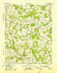
1943 Map of Thorofare Gap
USGS Topo · Published 1960About this map
The Bull Run Mountains form a dramatic natural spine through this mid-century survey, creating the prominent Thorofare Gap and Hopewell Gap that have long dictated transport and settlement patterns between Fauquier and Prince William counties. The Southern railroad and primary roads utilize these natural breaks in the ridge, connecting rural hubs like Haymarket and Broad Run. In the southern portion of the sheet, the Vint Hill Farm Military Reservation occupies a significant tract of land, reflecting the era's military footprint in Northern Virginia.
Find a feature on this map
40 named features on this map. Tap any name to fly to it.
Don’t see what you’re looking for? This feature index may not catch every label — zoom into the map to look around manually.
Map Details
Editions of this 1943 Thorofare Gap Map
This is the sole edition of this map. No revisions or reprints were ever made.
Other maps of this area

1894 · Warrenton
USGS Topo · 1:125,000

1894 · Warrenton
USGS Topo · 1:62,500

1927 · Remington
USGS Topo · 1:48,000

1930 · Warrenton
USGS Topo · 1:62,500

1933 · Middleburg
USGS Topo · 1:62,500

1943 · Catlett
USGS Topo · 1:62,500

1943 · Arcola
USGS Topo · 1:24,000

1943 · Marshall
USGS Topo · 1:24,000

1943 · Rectortown
USGS Topo · 1:24,000
1944 · Arcola
USGS Topo · 1:31,680