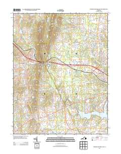
2013 Map of Thoroughfare Gap
USGS Topo · Published 2013About this map
Broad Run and Little Bull Run carve through the landscape of Northern Virginia, defining the settlement patterns and industrial history of this region. The geographic bottleneck of Thoroughfare is anchored by the historic Beverley Mill, while the surrounding terrain rises toward High Point Mountain and Bisquit Mountain. This survey documents a transition from established rural hamlets like Buckland and Greenwich to the expanding suburban residential development around Haymarket. Further north, smaller communities such as Waterfall Village and Antioch remain tied to the network of winding country roads. Large water features including Lake Manassas, Silver Lake, and Lake Brittle punctuate the landscape, alongside landmarks like Camp William B. Snyder, illustrating the area's diverse land use.
Find a feature on this map
140 named features on this map. Tap any name to fly to it.
Don’t see what you’re looking for? This feature index may not catch every label — zoom into the map to look around manually.
Map Details
Editions of this 2013 Thoroughfare Gap Map
This is the sole edition of this map. No revisions or reprints were ever made.
Other maps of this area

1894 · Warrenton
USGS Topo · 1:125,000

1894 · Warrenton
USGS Topo · 1:62,500

1927 · Remington
USGS Topo · 1:48,000

1930 · Warrenton
USGS Topo · 1:62,500

1933 · Middleburg
USGS Topo · 1:62,500

1943 · Catlett
USGS Topo · 1:62,500

1943 · Arcola
USGS Topo · 1:24,000

1943 · Thorofare Gap
USGS Topo · 1:24,000

1943 · Marshall
USGS Topo · 1:24,000

1943 · Rectortown
USGS Topo · 1:24,000