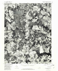
1977 Map of Thoroughfare Gap
USGS Topo · Published 1982About this map
Bull Run and Broad Run carve through the foothills of the Mountains in this late-1970s orthophotoquad, documenting the landscape of Prince William and Fauquier counties. The aerial imagery captures the area at a transitional moment, showing the historical footprint of Haymarket and Buckland alongside emerging development. The significant geographic break at Thoroughfare Gap serves as a focal point for transportation and water drainage, while Lake Manassas and Silver Lake appear as prominent features in the eastern half of the survey. The orthophoto format provides an authentic visual of land use patterns, from the clustered crossroads at Antioch to the rural expanses near New Baltimore and the smaller settlement of Thoroughfare.
Find a feature on this map
13 named features on this map. Tap any name to fly to it.
Don’t see what you’re looking for? This feature index may not catch every label — zoom into the map to look around manually.
Map Details
Editions of this 1977 Thoroughfare Gap Map
This is the sole edition of this map. No revisions or reprints were ever made.
Other maps of this area

1894 · Warrenton
USGS Topo · 1:125,000

1894 · Warrenton
USGS Topo · 1:62,500

1927 · Remington
USGS Topo · 1:48,000

1930 · Warrenton
USGS Topo · 1:62,500

1933 · Middleburg
USGS Topo · 1:62,500

1943 · Catlett
USGS Topo · 1:62,500

1943 · Arcola
USGS Topo · 1:24,000

1943 · Thorofare Gap
USGS Topo · 1:24,000

1943 · Marshall
USGS Topo · 1:24,000

1943 · Rectortown
USGS Topo · 1:24,000