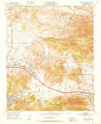
1952 Map of Thousand Oaks
USGS Topo · Published 1952About this map
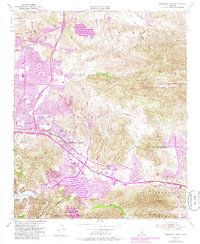
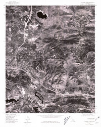
Thousand Oaks and its surrounding ranchlands are depicted here in the early 1950s, shortly before the rapid suburbanization of the El Conejo valley. The map shows a landscape defined by traditional cattle ranching and early aviation, centered around the Conejo Valley Airport and the historic Lang Ranch. Significant local infrastructure is visible, including the Ventura Blvd corridor and the Norwegian Grade, which connect the valley to the rugged Simi Hills and Santa Monica Mountains. South of the main settlement, Lake Sherwood and Lake Eleanor sit within the Russell Valley, providing a look at the established recreation and residential patterns near Triunfo Corner. The presence of the Olson Cem and the Conejo Sch highlights the civic foundations of this community during its transition from a rural outpost to a modern residential hub.
Find a feature on this map
39 named features on this map. Tap any name to fly to it.
Don’t see what you’re looking for? This feature index may not catch every label — zoom into the map to look around manually.
Map Details
Editions of this 1952 Thousand Oaks Map
This is the sole edition of this map. No revisions or reprints were ever made.
Historical Maps of Thousand Oaks Through Time
7 maps found