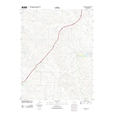
2012 Map of Thrall NW
USGS Topo · Published 2012About this map
The N Br Verdigris River and its network of tributaries define this part of Chase County, where the hydrology reveals a landscape shaped by drainage basins. Multiple branches of Sharpes Cr, including the E Br Sharpes Cr, flow through the western and central portions of the quadrangle, while Norton Cr and Bloody Cr mark the northern reaches. The area is predominantly rural, with the drainage patterns of Bull Cr and Shaw Cr suggesting the low-lying prairie terrain typical of the region. A single primary thoroughfare, Road 50, provides the main terrestrial connection through this drainage-heavy landscape, cutting across the watershed of Wolf Cr and Camp Cr.
Find a feature on this map
12 named features on this map. Tap any name to fly to it.
Don’t see what you’re looking for? This feature index may not catch every label — zoom into the map to look around manually.
Map Details
Editions of this 2012 Thrall NW Map
This is the sole edition of this map. No revisions or reprints were ever made.
Other maps of this area

1888 · Emporia
USGS Topo · 1:125,000

1894 · Emporia
USGS Topo · 1:125,000

1898 · Cottonwood Falls
USGS Topo · 1:125,000

1955 · Hutchinson
USGS Topo · 1:250,000

1959 · Hutchinson
USGS Topo · 1:250,000
1967 · Thrall
USGS Topo · 1:24,000
1967 · Teterville
USGS Topo · 1:24,000
1967 · Matfield Green SE
USGS Topo · 1:24,000

1973 · Matfield Green
USGS Topo · 1:24,000

1973 · Shaw Creek
USGS Topo · 1:24,000