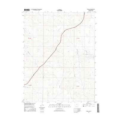
2015 Map of Thrall NW
USGS Topo · Published 2015About this map
N Br Verdigris River and its numerous tributaries define the drainage patterns of this Chase County landscape. The topography is shaped by the complex network of Sharpes Cr and E Br Sharpes Cr in the west, while Norton Cr and Bloody Cr flow through the northern reaches. This 2015 survey illustrates a rural environment primarily organized around watershed boundaries and section lines, with essential transit routes like Sharpes Creek Rd and Camp Creek Rd providing access to the interior. The map also identifies specific land management routes such as Pasture Access Rd and sections where permission is required for entry. The abundance of named watercourses, including Bull Cr and Shaw Cr, highlights the significant creek systems that sustain the ranching and agricultural life of the region.
Find a feature on this map
21 named features on this map. Tap any name to fly to it.
Don’t see what you’re looking for? This feature index may not catch every label — zoom into the map to look around manually.
Map Details
Editions of this 2015 Thrall NW Map
This is the sole edition of this map. No revisions or reprints were ever made.
Other maps of this area

1888 · Emporia
USGS Topo · 1:125,000

1894 · Emporia
USGS Topo · 1:125,000

1898 · Cottonwood Falls
USGS Topo · 1:125,000

1955 · Hutchinson
USGS Topo · 1:250,000

1959 · Hutchinson
USGS Topo · 1:250,000
1967 · Thrall
USGS Topo · 1:24,000
1967 · Teterville
USGS Topo · 1:24,000
1967 · Matfield Green SE
USGS Topo · 1:24,000

1973 · Matfield Green
USGS Topo · 1:24,000

1973 · Shaw Creek
USGS Topo · 1:24,000