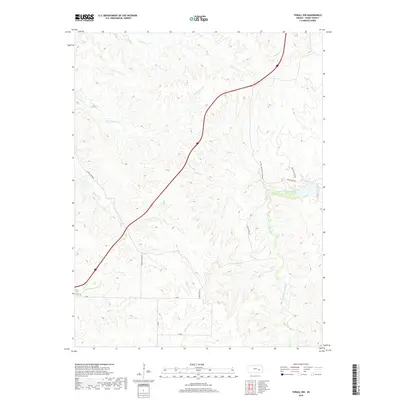
2018 Map of Thrall NW
USGS Topo · Published 2018About this map
The North Branch Verdigris River and its numerous tributaries carve a complex drainage pattern across this section of Chase County. The landscape is defined by the headwaters of several key creeks, including Little Cedar Cr, Shaw Cr, and Norton Cr, which dictate the local topography and the winding paths of rural thoroughfares. These roads, such as Sharps Creek Rd and Camp Creek Rd, typically follow the ridges or valley floors established by the watercourses, illustrating how the drainage network of the Verdigris watershed has historically shaped regional movement. Much of the land remains restricted, as evidenced by notations for Pvt Rd - Permission Required and specific Pasture Access Rd segments, reflecting the predominantly private ranching and agricultural character of the area in the late 2010s.
Find a feature on this map
24 named features on this map. Tap any name to fly to it.
Don’t see what you’re looking for? This feature index may not catch every label — zoom into the map to look around manually.
Map Details
Editions of this 2018 Thrall NW Map
This is the sole edition of this map. No revisions or reprints were ever made.
Other maps of this area

1888 · Emporia
USGS Topo · 1:125,000

1894 · Emporia
USGS Topo · 1:125,000

1898 · Cottonwood Falls
USGS Topo · 1:125,000

1955 · Hutchinson
USGS Topo · 1:250,000

1959 · Hutchinson
USGS Topo · 1:250,000
1967 · Thrall
USGS Topo · 1:24,000
1967 · Teterville
USGS Topo · 1:24,000
1967 · Matfield Green SE
USGS Topo · 1:24,000

1973 · Matfield Green
USGS Topo · 1:24,000

1973 · Shaw Creek
USGS Topo · 1:24,000