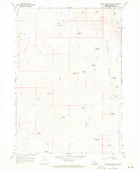
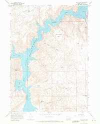
1967 Map of Three Fingers Rock
USGS Topo · Published 1971About this map
Three Fingers Rock stands as the central landmark in this high-desert landscape of eastern Malheur County, Oregon, during the late 1960s. The terrain is defined by the prominent McIntyre Ridge and several notable water sources essential for cattle ranching in this arid climate, including McIntyre Reservoir and Saddle Butte Reservoir. Human activity is primarily represented by a network of jeep trails and historic ranching improvements, such as the Camp Cabin near Sage Creek and isolated springs like Buzzard Spring and Horse Trap Spring. The map documents a landscape of dramatic topography, from the depths of Painted Canyon to the heights of Round Mountain and Atkins Butte. This survey provides a record of the remote infrastructure of the Owyhee region, showing the placement of mines and the seasonal water management systems used by early 20th-century settlers and ranchers.
Find a feature on this map
30 named features on this map. Tap any name to fly to it.
Don’t see what you’re looking for? This feature index may not catch every label — zoom into the map to look around manually.
Map Details
Editions of this 1967 Three Fingers Rock Map
This is the sole edition of this map. No revisions or reprints were ever made.
Other maps of this area

1906 · Mitchell Butte
USGS Topo · 1:125,000

1955 · Boise
USGS Topo · 1:250,000

1958 · Boise
USGS Topo · 1:250,000

1962 · Boise
USGS Topo · 1:250,000
1967 · Graveyard Point
USGS Topo · 1:24,000

1967 · Pelican Point
USGS Topo · 1:24,000

1967 · Rockville
USGS Topo · 1:24,000
1967 · Pole Creek Top
USGS Topo · 1:24,000
1967 · Bannock Ridge
USGS Topo · 1:24,000
1967 · The Elbow
USGS Topo · 1:24,000