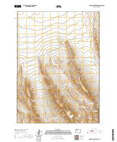
2020 Map of Three Man Butte Well
USGS Topo · Published 2020About this map
Three Man Butte Well centers a high-desert landscape in southeastern Malheur County, where the infrastructure of livestock ranching and water management is paramount. The terrain is marked by a series of critical catchments including Bedground Reservoir, Short Draw Reservoir, and Ledge Rock Reservoir, which highlight the necessity of water security in this arid region. Transportation is facilitated by the long stretch of Whitehorse Rd and the Old Ion Hwy along the eastern edge, routes that have historically connected these isolated grazing lands to wider markets. The map reveals a land divided by township and range lines such as t36s r41e and t37s r41e, illustrating the systematic organization of the Oregon outback.
Find a feature on this map
12 named features on this map. Tap any name to fly to it.
Don’t see what you’re looking for? This feature index may not catch every label — zoom into the map to look around manually.
Map Details
Editions of this 2020 Three Man Butte Well Map
This is the sole edition of this map. No revisions or reprints were ever made.
Other maps of this area

1955 · Jordan Valley
USGS Topo · 1:250,000

1955 · Adel
USGS Topo · 1:250,000

1957 · Adel
USGS Topo · 1:250,000

1957 · Jordan Valley
USGS Topo · 1:250,000

1958 · Adel
USGS Topo · 1:250,000

1958 · Jordan Valley
USGS Topo · 1:250,000

1962 · Adel
USGS Topo · 1:250,000

1979 · Flat Top Mtn SE
USGS Topo · 1:24,000

1980 · Rome State Airport
USGS Topo · 1:24,000
1981 · Coyote Lake East
USGS Topo · 1:24,000