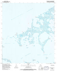
1994 Map of Three Mile Bay
USGS Topo · Published 1994About this map
The vast salt marshes and intricate wetlands of St. Bernard Parish are meticulously detailed in this study of the coastal Louisiana landscape. Defined by the transition from the open Mississippi Sound to the protected waters of Three Mile Bay, the area is a labyrinth of tidal passages and named points. Notable landmarks such as Negro Point and Shell Point provide reference across the fragmented shoreline, while a network of bayous including Turkey Bayou, Johnson Bayou, and Picnic Bayou weave through the marshland.
Find a feature on this map
19 named features on this map. Tap any name to fly to it.
Don’t see what you’re looking for? This feature index may not catch every label — zoom into the map to look around manually.
Map Details
Editions of this 1994 Three Mile Bay Map
This is the sole edition of this map. No revisions or reprints were ever made.
Other maps of this area

1893 · Cat Island
USGS Topo · 1:62,500

1893 · Chandeleur
USGS Topo · 1:62,500

1893 · Toulme
USGS Topo · 1:62,500

1895 · Bodreau
USGS Topo · 1:62,500

1935 · Grand Island Pass
USGS Topo · 1:31,680

1935 · Mitchell Keys
USGS Topo · 1:31,680

1946 · Oak Mound Bayou
USGS Topo · 1:31,680

1946 · Isle Au Pitre
USGS Topo · 1:31,680

1946 · Lake Eugenie
USGS Topo · 1:31,680

1946 · Malheureux Point
USGS Topo · 1:31,680