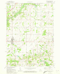
1970 Map of Three Oaks
USGS Topo · Published 1973About this map
The village of Three Oaks anchors this study of the Michigan-Indiana borderlands, where the Chesapeake and Ohio railroad corridor cuts through a landscape defined by the winding Galien River. The transition from the rural township of Chikaming into the northern reaches of La Porte County, Indiana, is marked by a high density of local landmarks, including the sprawling Warren Woods State Park and family-named cemeteries like Riverside Cem and Forest Lawn Cem.
Find a feature on this map
53 named features on this map. Tap any name to fly to it.
Don’t see what you’re looking for? This feature index may not catch every label — zoom into the map to look around manually.
Map Details
Editions of this 1970 Three Oaks Map
This is the sole edition of this map. No revisions or reprints were ever made.
Other maps of this area

1927 · Niles
USGS Topo · 1:62,500

1930 · Three Oaks
USGS Topo · 1:62,500

1930 · Niles
USGS Topo · 1:62,500

1943 · Niles
USGS Topo · 1:62,500

1944 · Three Oaks
USGS Topo · 1:62,500

1953 · Chicago
USGS Topo · 1:250,000

1957 · Chicago
USGS Topo · 1:250,000

1958 · Lydick
USGS Topo · 1:24,000

1958 · Springville
USGS Topo · 1:24,000

1958 · New Carlisle
USGS Topo · 1:24,000