
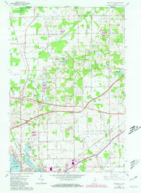
1958 Map of Springville
USGS Topo · Published 1964About this map
Springville and Hesston anchor this La Porte County landscape in the late 1950s, a period defined by the convergence of traditional rural settlements and modern transportation infrastructure. The newly constructed Indiana Toll Road cuts a wide swath across the center of the sheet, intersecting the established paths of the Chicago South Shore and South Bend Railroad and the New York Central Railroad. This transportation network serves a region of diverse terrain, from the northern Crosby Marsh to the southern shores of Pine Lake and Fishrap Lake.
Find a feature on this map
40 named features on this map. Tap any name to fly to it.
Don’t see what you’re looking for? This feature index may not catch every label — zoom into the map to look around manually.
Map Details
Editions of this 1958 Springville Map
2 editions found
Other maps of this area

1930 · Three Oaks
USGS Topo · 1:62,500

1944 · Three Oaks
USGS Topo · 1:62,500

1953 · Chicago
USGS Topo · 1:250,000

1957 · Chicago
USGS Topo · 1:250,000

1958 · Stillwell
USGS Topo · 1:24,000

1958 · Michigan City East
USGS Topo · 1:24,000

1958 · La Porte East
USGS Topo · 1:24,000

1958 · New Carlisle
USGS Topo · 1:24,000
1961 · La Porte West
USGS Topo · 1:24,000
1969 · La Porte West
USGS Topo · 1:24,000