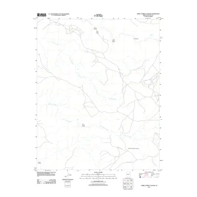
2011 Map of Three Turkey Canyon
USGS Topo · Published 2011About this map
Tiis Ndiitsooi Wash and Tse Deeshzhaai Wash carve a network of drainage channels across this high-desert landscape in Apache County. This 2011 survey illustrates the topography of the Chinle Agency region, where dramatic geological formations define the character of the land. Significant natural landmarks include Three Turkey Natural Bridge and the The Window, alongside prominent vistas like Sliding Rock Overlook. The area is interlaced with Navajo Nation infrastructure, notably Indian Rte-7 and Indian Rte-8015, which navigate the complex terrain of Three Turkey Canyon and Seachi Canyon. For researchers and historians, the map preserves the exact alignment of these routes and the locations of water resources such as Tatezaka Tank, documenting the intersection of natural erosion and modern transport in the early 21st century.
Find a feature on this map
13 named features on this map. Tap any name to fly to it.
Don’t see what you’re looking for? This feature index may not catch every label — zoom into the map to look around manually.
Map Details
Editions of this 2011 Three Turkey Canyon Map
This is the sole edition of this map. No revisions or reprints were ever made.
Other maps of this area

1886 · Fort Defiance
USGS Topo · 1:250,000

1892 · Fort Defiance
USGS Topo · 1:250,000

1892 · Canyon De Chelly
USGS Topo · 1:250,000

1954 · Shiprock
USGS Topo · 1:250,000

1954 · Gallup
USGS Topo · 1:250,000

1955 · Chinle 4 NE
USGS Topo · 1:24,000

1955 · Zith-Tusayan Butte 2 NW
USGS Topo · 1:24,000

1955 · Chinle 4 SE
USGS Topo · 1:24,000

1955 · Zith-Tusayan Butte 2 NE
USGS Topo · 1:24,000

1955 · Sonsala Butte 3 SE
USGS Topo · 1:24,000