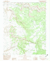
1983 Map of Three Turkey Canyon
USGS Topo · Published 1983About this map
Three Turkey Ruins Navajo Tribal Park preserves a significant archaeological site within the Navajo Indian Reservation, showcasing the layered history of ancestral Puebloan habitation in northern Arizona. The landscape is defined by deep incisions like Three Turkey Wash Canyon and Cottonwood Canyon, where cliff dwellings and masonry structures are sheltered by sandstone overhangs. Archaeological interest is dense here, with named sites such as Sliding Rock Ruins, White Sand Ruins, and the Beehive Ruins scattered across the canyon floor and walls.
Find a feature on this map
18 named features on this map. Tap any name to fly to it.
Don’t see what you’re looking for? This feature index may not catch every label — zoom into the map to look around manually.
Map Details
Editions of this 1983 Three Turkey Canyon Map
This is the sole edition of this map. No revisions or reprints were ever made.
Other maps of this area

1886 · Fort Defiance
USGS Topo · 1:250,000

1892 · Fort Defiance
USGS Topo · 1:250,000

1892 · Canyon De Chelly
USGS Topo · 1:250,000

1954 · Shiprock
USGS Topo · 1:250,000

1954 · Gallup
USGS Topo · 1:250,000

1955 · Chinle 4 NE
USGS Topo · 1:24,000

1955 · Zith-Tusayan Butte 2 NW
USGS Topo · 1:24,000

1955 · Chinle 4 SE
USGS Topo · 1:24,000

1955 · Zith-Tusayan Butte 2 NE
USGS Topo · 1:24,000

1955 · Sonsala Butte 3 SE
USGS Topo · 1:24,000