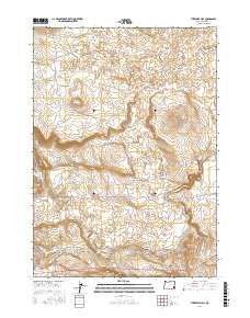
2017 Map of Threemile Hill
USGS Topo · Published 2017About this map
Merrill Springs Rim and Threemile Hill dominate this high-desert landscape in Oregon's remote southeast. The area is characterized by its vital water management infrastructure, featuring several irrigation and livestock sources including Saddle Butte Reservoir, Alkali Reservoir, and Hidden Reservoir. Transportation routes like the Old Ion Hwy and Lava Beds Rd cut across the arid terrain, providing access to landmarks such as Holdup Rock and Dixons Rock. The presence of the N Side Canal and S Side Canal drawing from Jordan Cr reveals the region's reliance on managed water systems to sustain ranching and agriculture in this volcanic and high-elevation environment. Geologic and land-use features like the Lequerica Trap further illustrate the human imprint on the high desert of Malheur County.
Find a feature on this map
21 named features on this map. Tap any name to fly to it.
Don’t see what you’re looking for? This feature index may not catch every label — zoom into the map to look around manually.
Map Details
Editions of this 2017 Threemile Hill Map
This is the sole edition of this map. No revisions or reprints were ever made.
Other maps of this area

1955 · Jordan Valley
USGS Topo · 1:250,000

1955 · Boise
USGS Topo · 1:250,000

1957 · Jordan Valley
USGS Topo · 1:250,000

1958 · Boise
USGS Topo · 1:250,000

1958 · Jordan Valley
USGS Topo · 1:250,000

1962 · Boise
USGS Topo · 1:250,000
1969 · Little Grassy Mountain
USGS Topo · 1:24,000

1969 · Jordan Craters South
USGS Topo · 1:24,000

1969 · Cow Lakes
USGS Topo · 1:24,000
1969 · Threemile Hill
USGS Topo · 1:24,000