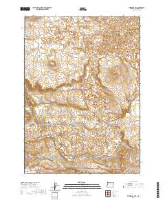
2020 Map of Threemile Hill
USGS Topo · Published 2020About this map
Jordan Creek and its associated irrigation network form the central axis of this landscape in Malheur County. The presence of the N Side Canal and S Side Canal underscores a managed water system designed to support life in the high desert. Historical transportation routes are prominent, with the Old Ion Hwy and Lava Beds Rd cutting across the terrain, indicating the pathways used to navigate this corner of Oregon.
Find a feature on this map
21 named features on this map. Tap any name to fly to it.
Don’t see what you’re looking for? This feature index may not catch every label — zoom into the map to look around manually.
Map Details
Editions of this 2020 Threemile Hill Map
This is the sole edition of this map. No revisions or reprints were ever made.
Other maps of this area

1955 · Jordan Valley
USGS Topo · 1:250,000

1955 · Boise
USGS Topo · 1:250,000

1957 · Jordan Valley
USGS Topo · 1:250,000

1958 · Boise
USGS Topo · 1:250,000

1958 · Jordan Valley
USGS Topo · 1:250,000

1962 · Boise
USGS Topo · 1:250,000
1969 · Little Grassy Mountain
USGS Topo · 1:24,000

1969 · Jordan Craters South
USGS Topo · 1:24,000

1969 · Cow Lakes
USGS Topo · 1:24,000
1969 · Threemile Hill
USGS Topo · 1:24,000