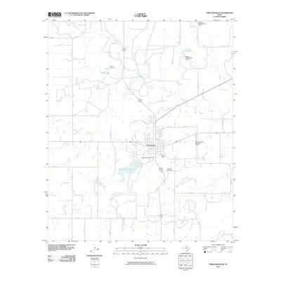
2010 Map of Throckmorton
USGS Topo · Published 2010About this map
Throckmorton serves as the central hub of this North Texas landscape, where the convergence of several county and farm-to-market roads meets at the town's grid. The surrounding area is defined by a series of water management features, including Lake Throckmorton and its associated Lake Throckmorton Dam south of the town center. The drainage pattern is complex, with North Elm Creek, Horse Creek, and Elm Creek winding through the terrain, punctuated by smaller impoundments like Brown Lake and Patterson Lake Number 1. These water sources were vital for the region's agricultural and ranching operations.
Find a feature on this map
35 named features on this map. Tap any name to fly to it.
Don’t see what you’re looking for? This feature index may not catch every label — zoom into the map to look around manually.
Map Details
Editions of this 2010 Throckmorton Map
This is the sole edition of this map. No revisions or reprints were ever made.
Other maps of this area

1954 · Wichita Falls
USGS Topo · 1:250,000

1958 · Wichita Falls
USGS Topo · 1:250,000

1962 · Antelope Creek SE
USGS Topo · 1:24,000

1965 · Throckmorton NE
USGS Topo · 1:24,000

1966 · Westover SE
USGS Topo · 1:24,000
1966 · Woodson
USGS Topo · 1:24,000

1966 · Westover SW
USGS Topo · 1:24,000
1966 · Reynolds Bend
USGS Topo · 1:24,000

1966 · Tonk Creek
USGS Topo · 1:24,000
1966 · Sibley Creek
USGS Topo · 1:24,000