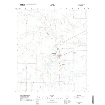
2019 Map of Throckmorton
USGS Topo · Published 2019About this map
Throckmorton serves as the central hub of this North Texas landscape, where a grid of town streets meets the winding paths of Elm Cr and N Elm Cr. The town plan is anchored by local landmarks such as the Po and the Throckmorton Municipal Airport, reflecting the civic infrastructure of this county seat. To the south, Lake Throckmorton provides a significant water resource, while the surrounding terrain is marked by family-named features like Patterson Lake Number 1 and Brown Lake, suggesting a history of private land management and ranching. The elevation rises toward the southeast at Thacker Mtn, offering a vantage point over a region defined by seasonal waterways like Flat Rock Cr and Horse Cr. This survey captures the transition between the managed municipal environment and the open drainage basins of the Brazos River watershed, providing researchers with a clear view of local property boundaries and road networks like Stock Pen RD.
Find a feature on this map
55 named features on this map. Tap any name to fly to it.
Don’t see what you’re looking for? This feature index may not catch every label — zoom into the map to look around manually.
Map Details
Editions of this 2019 Throckmorton Map
This is the sole edition of this map. No revisions or reprints were ever made.
Other maps of this area

1954 · Wichita Falls
USGS Topo · 1:250,000

1958 · Wichita Falls
USGS Topo · 1:250,000

1962 · Antelope Creek SE
USGS Topo · 1:24,000

1965 · Throckmorton NE
USGS Topo · 1:24,000

1966 · Westover SE
USGS Topo · 1:24,000
1966 · Woodson
USGS Topo · 1:24,000

1966 · Westover SW
USGS Topo · 1:24,000
1966 · Reynolds Bend
USGS Topo · 1:24,000

1966 · Tonk Creek
USGS Topo · 1:24,000
1966 · Sibley Creek
USGS Topo · 1:24,000