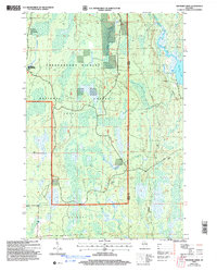
2005 Map of Thunder Creek
USGS Topo · Published 2006About this map
The Chequamegon-Nicolet National Forest dominates this northern Wisconsin landscape, captured here in a survey revised at the start of the twenty-first century. This territory is characterized by its dense water networks and forest management areas, including the Elk Valley Semi-Primitive Non Motorized Area in the northwest corner. The map traces the winding course of Thunder Creek, which cuts across the central townships of Emery and Lynne, eventually feeding toward the significant waters of Willow Lake on the eastern boundary.
Find a feature on this map
17 named features on this map. Tap any name to fly to it.
Don’t see what you’re looking for? This feature index may not catch every label — zoom into the map to look around manually.
Map Details
Editions of this 2005 Thunder Creek Map
This is the sole edition of this map. No revisions or reprints were ever made.
Other maps of this area

1938 · Lac Du Flambeau
USGS Topo · 1:48,000

1939 · Lac Du Flambeau
USGS Topo · 1:48,000

1939 · Mc Cord
USGS Topo · 1:48,000

1941 · Pike Lake
USGS Topo · 1:48,000

1941 · Brantwood
USGS Topo · 1:48,000

1942 · Pike Lake
USGS Topo · 1:48,000

1943 · Brantwood
USGS Topo · 1:48,000

1946 · Lac Du Flambeau
USGS Topo · 1:48,000

1947 · Mc Cord
USGS Topo · 1:48,000

1950 · Pike Lake
USGS Topo · 1:48,000