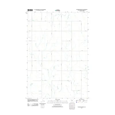
2012 Map of Thunder Hawk SE
USGS Topo · Published 2012About this map
Willow Cr winds through this section of the Rock Creek District in Corson County, shaping the drainage patterns of an open prairie landscape. Surveyed in the early 21st century, the map reveals a strictly regulated grid of section lines and rural corridors, including 106th St and 112th St. The intersection of north-south routes like 214th Ave and 217th Ave defines the modern agricultural layout of this Dakota territory. While primarily a map of topography and hydrology, the precise placement of these rural roads reflects the enduring homestead-era division of land that continues to dictate movement across the plains of northern South Dakota.
Find a feature on this map
15 named features on this map. Tap any name to fly to it.
Don’t see what you’re looking for? This feature index may not catch every label — zoom into the map to look around manually.
Map Details
Editions of this 2012 Thunder Hawk SE Map
This is the sole edition of this map. No revisions or reprints were ever made.
Other maps of this area

1953 · McIntosh
USGS Topo · 1:250,000

1956 · Cottonwood Creek NW
USGS Topo · 1:24,000

1958 · McIntosh
USGS Topo · 1:250,000

1972 · Morristown
USGS Topo · 1:24,000

1972 · Black Horse Butte NW
USGS Topo · 1:24,000

1972 · Skull Butte
USGS Topo · 1:24,000

1972 · Thunder Hawk SW
USGS Topo · 1:24,000

1972 · Thunder Hawk SE
USGS Topo · 1:24,000
1972 · Keldron
USGS Topo · 1:24,000
1972 · Thunder Hawk
USGS Topo · 1:24,000