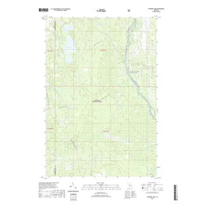
2019 Map of Thunder Lake
USGS Topo · Published 2019About this map
Hiawatha National Forest dominates this landscape in the Upper Peninsula, where an intricate network of wetlands and glacial lakes defines the terrain. The central hydrology is anchored by Thunder Lake and the Indian Wild and Scenic River, which serves as a protected corridor along the eastern edge of the quadrangle. This area is characterized by its seasonal recreational infrastructure, featuring the Indian River Canoe Route (Water) and extensive winter paths such as the Murphy Creek Trail (Snow) and the Big Spring-Baldy Lake Snomo (Snow). Small named water bodies like Frankes Lake, Bear Lake, and Cranberry Lake are scattered throughout the forest, while the southwestern corner near Big Spring and Gerometta Dr shows the minimal road development allowed in this protected timberland and watershed.
Find a feature on this map
24 named features on this map. Tap any name to fly to it.
Don’t see what you’re looking for? This feature index may not catch every label — zoom into the map to look around manually.
Map Details
Editions of this 2019 Thunder Lake Map
This is the sole edition of this map. No revisions or reprints were ever made.
Other maps of this area

1931 · Cooks NE
USGS Topo · 1:31,680

1931 · Steuben SE
USGS Topo · 1:31,680

1931 · Steuben SW
USGS Topo · 1:31,680

1931 · Steuben NE
USGS Topo · 1:31,680

1931 · Cooks NW
USGS Topo · 1:31,680

1931 · Steuben NW
USGS Topo · 1:31,680

1931 · Skeels Lake NE
USGS Topo · 1:31,680

1932 · Skeels Lake SE
USGS Topo · 1:31,680

1932 · Garden NE
USGS Topo · 1:31,680

1954 · Escanaba
USGS Topo · 1:250,000