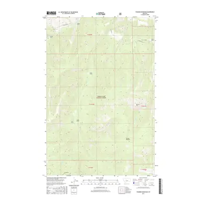
2017 Map of Thunder Mountain
USGS Topo · Published 2017About this map
Thunder Mountain rises as a prominent landmark in this 2017 survey of the Highwood Mountains region within the Lewis & Clark National Forest. The landscape is defined by a dense network of drainages and named gulches that reveal the area's geological and industrial history. Headwaters for Belt Cr and its tributaries, including Pilgrim Cr and Thunder Cr, carve through the terrain, while landmarks like Big Horn Mtn and Mt Pilgrim provide vertical relief. The presence of Sawmill Gulch and Tobins Gulch in the northwest suggests early resource extraction patterns. Access is limited to routes such as Logging Creek Rd and Jamestown Ln, indicating a sparsely populated wilderness area primarily used for forestry and recreation near the turn of the 21st century.
Find a feature on this map
27 named features on this map. Tap any name to fly to it.
Don’t see what you’re looking for? This feature index may not catch every label — zoom into the map to look around manually.
Map Details
Editions of this 2017 Thunder Mountain Map
This is the sole edition of this map. No revisions or reprints were ever made.
Other maps of this area

1886 · Great Falls
USGS Topo · 1:250,000

1886 · Fort Logan
USGS Topo · 1:250,000

1886 · Little Belt Mts.
USGS Topo · 1:250,000

1890 · Fort Benton
USGS Topo · 1:250,000

1892 · Fort Benton
USGS Topo · 1:250,000

1894 · Little Belt Mts.
USGS Topo · 1:250,000

1897 · Fort Benton
USGS Topo · 1:250,000

1897 · Little Belt Mts.
USGS Topo · 1:250,000

1898 · Little Belt Mts.
USGS Topo · 1:250,000

1902 · Little Belt Mts.
USGS Topo · 1:250,000