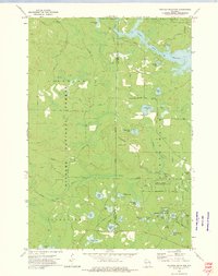
1972 Map of Thunder Mountain
USGS Topo · Published 1975About this map
Nicolet National Forest encompasses much of this Wisconsin landscape, where the Peshtigo River feeds into the expansive Caldron Falls Reservoir. The terrain is defined by Thunder Mountain and its associated landmarks, including a Lookout Tower and Thunder Mountain Falls. Local recreation and conservation are evident through the Camp Bird State Youth Recreational Center and the Thunder River State Rearing Station, reflecting the mid-century focus on land management and public youth services. Numerous small lakes such as Fryingpan Lake, Ledge Lake, and Bottle Lake are scattered throughout the wooded sectors, connected by a network of rural routes like Bucks Ranch Road and Martin Lane. The map details a transition from the wilder forest interiors to the more developed edges near Thunder Mountain Ranch and various public access points.
Find a feature on this map
51 named features on this map. Tap any name to fly to it.
Don’t see what you’re looking for? This feature index may not catch every label — zoom into the map to look around manually.
Map Details
Editions of this 1972 Thunder Mountain Map
2 editions found
Other maps of this area

1940 · Thunder Mtn.
USGS Topo · 1:48,000

1940 · Athelstane
USGS Topo · 1:48,000

1941 · Coleman
USGS Topo · 1:48,000

1942 · Athelstane
USGS Topo · 1:48,000

1942 · Coleman
USGS Topo · 1:48,000

1942 · Breed
USGS Topo · 1:48,000

1950 · Coleman
USGS Topo · 1:48,000

1951 · Thunder Mountain
USGS Topo · 1:48,000

1952 · Mountain
USGS Topo · 1:48,000

1954 · Iron Mountain
USGS Topo · 1:250,000