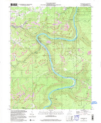
1997 Map of Thurmond
USGS Topo · Published 2001About this map
New River Gorge National River defines the central axis of this West Virginia study, where the rugged terrain of the Plateau drops sharply toward the water. The corridor is shaped by the industrial legacy of the New River, characterized by numerous strip mines, quarries, and extensive rail infrastructure including 3 Tracks and several conveyor systems. Settlements like Thurmond and Beury are perched along the riverbanks, serving as focal points for the region's historic mining and rail activity.
Find a feature on this map
64 named features on this map. Tap any name to fly to it.
Don’t see what you’re looking for? This feature index may not catch every label — zoom into the map to look around manually.
Map Details
Editions of this 1997 Thurmond Map
This is the sole edition of this map. No revisions or reprints were ever made.
Other maps of this area

1887 · Hinton
USGS Topo · 1:125,000

1889 · Nicholas
USGS Topo · 1:125,000

1891 · Nicholas
USGS Topo · 1:125,000

1891 · Raleigh
USGS Topo · 1:125,000

1892 · Hinton
USGS Topo · 1:125,000

1897 · Kanawha Falls
USGS Topo · 1:125,000

1897 · Raleigh
USGS Topo · 1:125,000

1900 · Kanawha Falls
USGS Topo · 1:125,000

1901 · Nicholas
USGS Topo · 1:125,000

1901 · Kanawha Falls
USGS Topo · 1:125,000