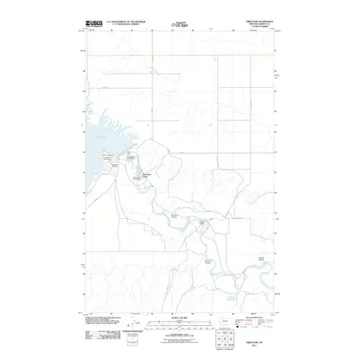
2011 Map of Tiber Dam
USGS Topo · Published 2011About this map
Tiber Dam stands as the central engineering feat of this landscape, holding back the expansive waters of Lake Elwell and regulating the southward flow of the Marias River. The infrastructure surrounding the dam supports both utility and recreation, featuring the Tiber Dam Camp and the Tiber Dam Airport alongside a concentration of public spaces including the VFW Campground, Tiber Marina Campground, and Sanford Park Campground.
Find a feature on this map
18 named features on this map. Tap any name to fly to it.
Don’t see what you’re looking for? This feature index may not catch every label — zoom into the map to look around manually.
Map Details
Editions of this 2011 Tiber Dam Map
This is the sole edition of this map. No revisions or reprints were ever made.
Other maps of this area

1954 · Shelby
USGS Topo · 1:250,000

1958 · Shelby
USGS Topo · 1:250,000

1970 · Circle Bridge
USGS Topo · 1:24,000

1970 · Carlson Coulee
USGS Topo · 1:24,000

1970 · Uphill Creek
USGS Topo · 1:24,000

1970 · Sagebrush Coulee
USGS Topo · 1:24,000

1970 · Goose Bill Butte NW
USGS Topo · 1:24,000

1970 · Poverty Coulee
USGS Topo · 1:24,000

1970 · Lothair SW
USGS Topo · 1:24,000
1970 · Lothair
USGS Topo · 1:24,000