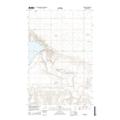
2014 Map of Tiber Dam
USGS Topo · Published 2014About this map
Tiber Dam and the sprawling waters of Lake Elwell dominate this Liberty County landscape, illustrating the mid-20th-century water management infrastructure along the Marias River. The map details the operations around Tiber Dam Camp and the small Tiber Dam Airport, reflecting the area's role in regional irrigation and recreation. The terrain is defined by deep, winding drainages such as Sixmile Coulee, Crooked Coulee, and Pondera Coulee, which cut through the high plains toward the river valley. Local transport is anchored by Pugsley Bridge and a network of rural routes including Pugsley Rd and MT-366. Further south, the presence of Pugsley Reservoir and Spring Coulee highlights the continued importance of water storage in this semi-arid ranching and farming corridor.
Find a feature on this map
23 named features on this map. Tap any name to fly to it.
Don’t see what you’re looking for? This feature index may not catch every label — zoom into the map to look around manually.
Map Details
Editions of this 2014 Tiber Dam Map
This is the sole edition of this map. No revisions or reprints were ever made.
Other maps of this area

1954 · Shelby
USGS Topo · 1:250,000

1958 · Shelby
USGS Topo · 1:250,000

1970 · Circle Bridge
USGS Topo · 1:24,000

1970 · Carlson Coulee
USGS Topo · 1:24,000

1970 · Uphill Creek
USGS Topo · 1:24,000

1970 · Sagebrush Coulee
USGS Topo · 1:24,000

1970 · Goose Bill Butte NW
USGS Topo · 1:24,000

1970 · Poverty Coulee
USGS Topo · 1:24,000

1970 · Lothair SW
USGS Topo · 1:24,000
1970 · Lothair
USGS Topo · 1:24,000