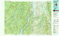
1989 Map of Ticonderoga
USGS Topo · Published 1989About this map
The Adirondack Park dominates the western half of this landscape, where the Schroon River flows through a series of significant water bodies including Schroon Lake and Paradox Lake. The eastern portion of the sheet transitions across the state line into Vermont, defined by the fertile valley between Lake Champlain and the Green Mountain National Forest. Central to this geography is the narrow connection between Lake George and Lake Champlain at Ticonderoga, a site of immense strategic importance during the colonial era and the American Revolution.
Find a feature on this map
190 named features on this map. Tap any name to fly to it.
Don’t see what you’re looking for? This feature index may not catch every label — zoom into the map to look around manually.
Map Details
Editions of this 1989 Ticonderoga Map
2 editions found
Other maps of this area

1891 · Rutland
USGS Topo · 1:62,500

1893 · Wallingford
USGS Topo · 1:62,500

1893 · Rutland
USGS Topo · 1:62,500

1893 · Fort Ann
USGS Topo · 1:62,500

1893 · Whitehall
USGS Topo · 1:62,500

1894 · Elizabethtown
USGS Topo · 1:62,500

1894 · Port Henry
USGS Topo · 1:62,500

1894 · Ticonderoga
USGS Topo · 1:62,500

1894 · Pawlet
USGS Topo · 1:62,500

1895 · Whitehall
USGS Topo · 1:62,500