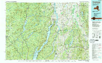
1989 Map of Ticonderoga
USGS Topo · Published 1989About this map
Adirondack Park dominates the western half of this 1989 region, where the Schroon River and Schroon Lake carve a north-south corridor through the mountains. To the east, across the narrow southern waters of Lake Champlain, the landscape shifts into the Green Mountains of Vermont. This map documents a borderland rich in Revolutionary War history, featuring the Mount Independence State Historic Site and Mount Defiance overlooking the strategic narrows.
Find a feature on this map
260 named features on this map. Tap any name to fly to it.
Don’t see what you’re looking for? This feature index may not catch every label — zoom into the map to look around manually.
Map Details
Editions of this 1989 Ticonderoga Map
2 editions found
Other maps of this area

1891 · Rutland
USGS Topo · 1:62,500

1893 · Wallingford
USGS Topo · 1:62,500

1893 · Rutland
USGS Topo · 1:62,500

1893 · Fort Ann
USGS Topo · 1:62,500

1893 · Whitehall
USGS Topo · 1:62,500

1894 · Elizabethtown
USGS Topo · 1:62,500

1894 · Port Henry
USGS Topo · 1:62,500

1894 · Ticonderoga
USGS Topo · 1:62,500

1894 · Pawlet
USGS Topo · 1:62,500

1895 · Whitehall
USGS Topo · 1:62,500