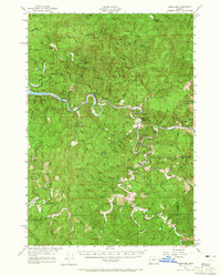
1956 Map of Tidewater
USGS Topo · Published 1965About this map
The Alsea River meanders through the heart of this coastal mountain landscape, tracing a path between steep timbered ridges and narrow valleys. This mid-century survey captures a transition in the Siuslaw National Forest, where the settlement of Tidewater serves as a small hub near the Tidewater Cem. The map reveals a network of forestry and agricultural life, evidenced by the State Fish Hatchery and several forest shelters like Threemile Shelter and Fivemile Shelter. To the south, the winding headwaters of the North Fork Yachats River pass near the Yachats Grange, where the Upper Yachats Sch (Aband) marks a shifting community footprint. Dramatic terrain features such as Cannibal Mtn and Stoney Mountain overlook the dense drainages of Lobster Creek and Canal Creek, illustrating the isolation of the interior ridges during this era.
Find a feature on this map
80 named features on this map. Tap any name to fly to it.
Don’t see what you’re looking for? This feature index may not catch every label — zoom into the map to look around manually.
Map Details
Editions of this 1956 Tidewater Map
3 editions found

Other maps of this area

1918 · Mapleton
USGS Topo · 1:48,000

1920 · Heceta Head
USGS Topo · 1:62,500

1922 · Waldport
USGS Topo · 1:62,500

1939 · Marys Peak
USGS Topo · 1:62,500

1940 · Mapleton
USGS Topo · 1:62,500

1941 · Blachly
USGS Topo · 1:62,500

1942 · Marys Peak
USGS Topo · 1:62,500

1942 · Alsea
USGS Topo · 1:62,500

1942 · Blachly
USGS Topo · 1:62,500

1942 · Waldport
USGS Topo · 1:62,500