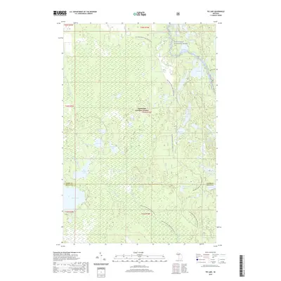
2019 Map of Tie Lake
USGS Topo · Published 2019About this map
The Hiawatha National Forest dominates this section of the Upper Peninsula, straddling the border between Alger and Delta counties. The landscape is defined by an intricate network of wetlands and small kettle lakes, including Tie Lake, McComb Lake, and Cluster Lakes. This map details a region managed for outdoor recreation and conservation, highlighting established corridors like Brunos Run and the Big Spring-Baldy Lake Snomo trail. The Sturgeon River and its West Branch meander through the western half, while specialized transit ways like the Sturgeon River Canoe Route and Indian River Canoe Route illustrate how the waterways themselves serve as primary infrastructure in this largely roadless forest interior. Smaller features like Slowfoot Lake and Skeels Pond offer specific points of interest for local geography and environmental study.
Find a feature on this map
47 named features on this map. Tap any name to fly to it.
Don’t see what you’re looking for? This feature index may not catch every label — zoom into the map to look around manually.
Map Details
Editions of this 2019 Tie Lake Map
This is the sole edition of this map. No revisions or reprints were ever made.
Other maps of this area

1931 · Skeels Lake NE
USGS Topo · 1:31,680

1931 · Munising SE
USGS Topo · 1:31,680

1932 · Skeels Lake SE
USGS Topo · 1:31,680

1932 · Trenary SE
USGS Topo · 1:31,680

1932 · Skeels Lake NW and SW
USGS Topo · 1:31,680

1958 · Corner Lake
USGS Topo · 1:62,500

1958 · Trenary
USGS Topo · 1:62,500

1958 · Munising
USGS Topo · 1:62,500

1958 · Au Train
USGS Topo · 1:62,500

1958 · Marquette
USGS Topo · 1:250,000