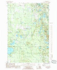
1985 Map of Tie Lake
USGS Topo · Published 1985About this map
The Hiawatha National Forest landscape within the Upper Peninsula of Michigan is defined by its dense density of glacial kettle lakes and a complex network of transportation corridors. This 1985 survey captures a transitional wilderness being managed for both resource extraction and recreation, evidenced by the proximity of the Old RR Grade and Nahma Grade to modern developments like the Snowmobile Trail. The hydrography is notably diverse, ranging from the central Tie Lake and McComb Lake to smaller, clustered waters such as Skeels Pond and Council Lake. The presence of Forest Highway 13 provides the primary north-south artery through this lake-rich territory, which straddles the boundary between Alger and Delta counties. Researchers can find evidence of the region's logging history in the numerous rail grades that still crisscross the forest floor, connecting former timber tracts to the larger watersheds.
Find a feature on this map
47 named features on this map. Tap any name to fly to it.
Don’t see what you’re looking for? This feature index may not catch every label — zoom into the map to look around manually.
Map Details
Editions of this 1985 Tie Lake Map
This is the sole edition of this map. No revisions or reprints were ever made.
Other maps of this area

1931 · Skeels Lake NE
USGS Topo · 1:31,680

1931 · Munising SE
USGS Topo · 1:31,680

1932 · Skeels Lake SE
USGS Topo · 1:31,680

1932 · Trenary SE
USGS Topo · 1:31,680

1932 · Skeels Lake NW and SW
USGS Topo · 1:31,680

1958 · Corner Lake
USGS Topo · 1:62,500

1958 · Trenary
USGS Topo · 1:62,500

1958 · Munising
USGS Topo · 1:62,500

1958 · Au Train
USGS Topo · 1:62,500

1958 · Marquette
USGS Topo · 1:250,000