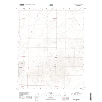
2018 Map of Tiefort Mountains
USGS Topo · Published 2018About this map
The Tiefort Mountains dominate the central landscape of this high desert terrain, where steep-sided massifs rise sharply from the Mojave Desert floor. This 2018 survey reveals the critical role of military operations in this region, anchored by the Bicycle Lake Army Airfield located on the western edge. The airfield is situated directly adjacent to Bicycle Lake, a distinctive dry lake bed that serves as a natural landing surface and focal point for regional infrastructure. Transportation through this arid environment is primary facilitated by Fort Irwin Rd, which cuts across the northern flats and provides access to the remote military installations. The map is heavily defined by the Public Land Survey System grid, with townships such as t14n r4e and t15n r4e marking out the desert sections and highlighting the organized division of this government-managed territory.
Find a feature on this map
11 named features on this map. Tap any name to fly to it.
Don’t see what you’re looking for? This feature index may not catch every label — zoom into the map to look around manually.
Map Details
Editions of this 2018 Tiefort Mountains Map
This is the sole edition of this map. No revisions or reprints were ever made.
Other maps of this area

1933 · Avawatz Mountains
USGS Topo · 1:250,000

1947 · Trona
USGS Topo · 1:250,000

1948 · Red Pass Lake
USGS Topo · 1:62,500

1948 · Trona
USGS Topo · 1:250,000

1948 · Alvord Mountain
USGS Topo · 1:62,500

1948 · Cave Mountain
USGS Topo · 1:62,500

1948 · Tiefort Mountains
USGS Topo · 1:62,500

1951 · Tiefort Mountains
USGS Topo · 1:62,500

1951 · Cave Mountain
USGS Topo · 1:62,500

1951 · Alvord Mountain
USGS Topo · 1:62,500