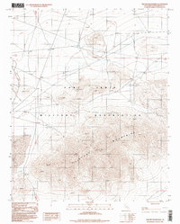
1996 Map of Tiefort Mountains
USGS Topo · Published 1998About this map
The Fort Irwin Military Reservation dominates this desert landscape, where high-altitude training and remote operations are etched into the terrain of San Bernardino County. In the late 20th century, the landscape is defined by the massive uplift of the Tiefort Mountains, which rise sharply above the basin of Bicycle Lake. This dry lake bed features a prominent Landing Strip, signaling the area's specialized aviation and logistical role within the military complex.
Find a feature on this map
11 named features on this map. Tap any name to fly to it.
Don’t see what you’re looking for? This feature index may not catch every label — zoom into the map to look around manually.
Map Details
Editions of this 1996 Tiefort Mountains Map
This is the sole edition of this map. No revisions or reprints were ever made.
Other maps of this area

1933 · Avawatz Mountains
USGS Topo · 1:250,000

1947 · Trona
USGS Topo · 1:250,000

1948 · Red Pass Lake
USGS Topo · 1:62,500

1948 · Trona
USGS Topo · 1:250,000

1948 · Alvord Mountain
USGS Topo · 1:62,500

1948 · Cave Mountain
USGS Topo · 1:62,500

1948 · Tiefort Mountains
USGS Topo · 1:62,500

1951 · Tiefort Mountains
USGS Topo · 1:62,500

1951 · Cave Mountain
USGS Topo · 1:62,500

1951 · Alvord Mountain
USGS Topo · 1:62,500