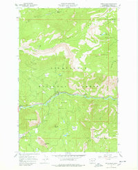
1967 Map of Tieton Basin
USGS Topo · Published 1978About this map
Bethel Ridge and Divide Ridge frame the high-elevation terrain of the Tieton Basin in this late-1960s survey of the Snoqualmie National Forest. The landscape is defined by the steep drainage of the Tieton River, which is supported by a network of seasonal camps including Wild Rose Campground and Hause Creek Campground. A Ranger Station and a Gaging Station monitor the river's flow near the eastern boundary, while the Tieton Emergency Airstrip provides a critical landing point in the valley floor near Rimrock Lake. High points such as Goose Egg Mountain and Kloochman Rock serve as major landmarks for navigation along the Rattlesnake Trail and various unnamed jeep tracks. The presence of the Jumpoff Lookout overlooking Jumpoff Meadows illustrates the era's active fire observation network in the central Cascades.
Find a feature on this map
42 named features on this map. Tap any name to fly to it.
Don’t see what you’re looking for? This feature index may not catch every label — zoom into the map to look around manually.
Map Details
Editions of this 1967 Tieton Basin Map
Other maps of this area

1899 · Ellensburg
USGS Topo · 1:125,000

1901 · Ellensburg
USGS Topo · 1:125,000

1902 · Mount Aix
USGS Topo · 1:125,000

1904 · Mt Aix
USGS Topo · 1:125,000

1950 · Yakima
USGS Topo · 1:250,000

1958 · Yakima
USGS Topo · 1:250,000

1961 · Yakima
USGS Topo · 1:250,000

1967 · Rimrock Lake
USGS Topo · 1:24,000

1967 · Tieton Basin
USGS Topo · 1:24,000

1967 · Darland Mtn
USGS Topo · 1:24,000