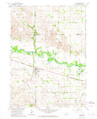
1963 Map of Tilden
USGS Topo · Published 1964About this map
The Elkhorn River winds through the heart of the Nebraska prairie in this mid-century survey, defining the boundaries between Antelope, Pierce, and Madison counties. At the center of the sheet, Tilden serves as a vital rail hub along the Chicago and North Western line, which cuts a straight path across the flat terrain of Jefferson and Burnett townships. This map captures a landscape transitioning between its agricultural foundations and the modernizing infrastructure of the early 1960s.
Find a feature on this map
28 named features on this map. Tap any name to fly to it.
Don’t see what you’re looking for? This feature index may not catch every label — zoom into the map to look around manually.
Map Details
Editions of this 1963 Tilden Map
This is the sole edition of this map. No revisions or reprints were ever made.
Other maps of this area

1955 · Sioux City
USGS Topo · 1:250,000

1955 · Fremont
USGS Topo · 1:250,000

1957 · Fremont
USGS Topo · 1:250,000

1958 · Sioux City
USGS Topo · 1:250,000

1958 · Fremont
USGS Topo · 1:250,000

1959 · Sioux City
USGS Topo · 1:250,000

1963 · Pierce NW
USGS Topo · 1:24,000
1963 · Oakdale
USGS Topo · 1:24,000

1963 · Emerick
USGS Topo · 1:24,000

1963 · Meadow Grove
USGS Topo · 1:24,000