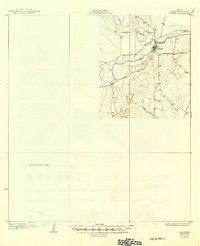
1930 Map of Tilden
USGS Topo · Published 1949About this map
The settlement of Tilden serves as the focal point for this survey of McMullen County, situated at a strategic crossing of the Frio River. Topography by W.B. Brewer reveals a landscape of intermittent drainages and distinct elevations, notably the Kings Hills rising south of the river valley. The map documents the early road network of the Brush Country, including the Calliham Road branching east from the town site. Much of the western portion of the sheet remains designated as an Unsurveyed Area, reflecting the transition from established ranching centers to the open frontier. The drainage patterns of Leoncita Creek and Kings Branch illustrate the hydrological character of this South Texas region during the mid-1920s.
Find a feature on this map
7 named features on this map. Tap any name to fly to it.
Don’t see what you’re looking for? This feature index may not catch every label — zoom into the map to look around manually.
Map Details
Editions of this 1930 Tilden Map
2 editions found
Other maps of this area

1920 · Mikeska
USGS Topo · 1:125,000

1925 · Tilden No. 1
USGS Topo · 1:48,000

1925 · Crowther No. 3
USGS Topo · 1:48,000

1925 · Simmons No. 2
USGS Topo · 1:48,000

1929 · Simmons
USGS Topo · 1:62,500

1930 · Tilden
USGS Topo · 1:62,500

1930 · Whitsett
USGS Topo · 1:62,500

1937 · Loma Alta
USGS Topo · 1:62,500

1942 · Fowlerton
USGS Topo · 1:62,500

1942 · Tilden
USGS Topo · 1:62,500