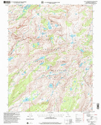
2001 Map of Tiltill Mountain
USGS Topo · Published 2004About this map
Yosemite National Park and the Emigrant Wilderness meet in this high-altitude landscape of the Sierra Nevada. The terrain is defined by a dense network of subalpine lakes and glaciated drainage basins, including Huckleberry Lake in the north and Lake Vernon to the southwest. Major watercourses like Jack Main Creek and Falls Creek carve through the granite, while the Pacific Crest National Scenic Trail traverses the eastern edge of the quadrangle near Tilden Creek. Significant peaks such as Tiltill Mountain, Michie Peak, and Kendrick Peak provide prominent landmarks across the wilderness boundary. The presence of Moraine Ridge and Bailey Ridge suggests the powerful glacial history that shaped these valleys, leaving behind scattered basins like Branigan Lake and Big Island Lake.
Find a feature on this map
45 named features on this map. Tap any name to fly to it.
Don’t see what you’re looking for? This feature index may not catch every label — zoom into the map to look around manually.
Map Details
Editions of this 2001 Tiltill Mountain Map
2 editions found
Other maps of this area

1896 · Dardanelles
USGS Topo · 1:125,000

1897 · Yosemite
USGS Topo · 1:125,000

1898 · Dardanelles
USGS Topo · 1:125,000

1900 · Yosemite
USGS Topo · 1:125,000

1903 · Yosemite
USGS Topo · 1:125,000

1909 · Yosemite
USGS Topo · 1:125,000

1947 · Mariposa
USGS Topo · 1:250,000

1948 · Walker Lake
USGS Topo · 1:250,000

1948 · Mariposa
USGS Topo · 1:250,000

1956 · Pinecrest
USGS Topo · 1:62,500