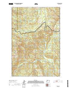
2020 Map of Timber
USGS Topo · Published 2020About this map
Timber and Glenwood sit at the core of this landscape on the Tillamook and Washington County line. The terrain is defined by a dense network of drainages including the Nehalem River, Lousignont Cr, and Gales Cr, illustrating the complex watershed of the Oregon Coast Range. High points like Round Top and the passage through Sunset Tunnel 2552 mark the elevations that govern movement through this region. Extensive trail systems, such as the Step Creek Trail and Gales Creek Trail, provide access to the interior, while Bauer Reservoir serves as a notable water management feature. This survey captures a modern view of a region defined by its timber history and its role as a corridor between the Willamette Valley and the coast.
Find a feature on this map
86 named features on this map. Tap any name to fly to it.
Don’t see what you’re looking for? This feature index may not catch every label — zoom into the map to look around manually.
Map Details
Editions of this 2020 Timber Map
This is the sole edition of this map. No revisions or reprints were ever made.
Other maps of this area

1940 · Vernonia
USGS Topo · 1:62,500

1941 · Keasey
USGS Topo · 1:62,500

1941 · Timber
USGS Topo · 1:62,500

1941 · Gales Creek
USGS Topo · 1:62,500

1943 · Vernonia
USGS Topo · 1:62,500

1943 · Keasey
USGS Topo · 1:62,500

1948 · Vancouver
USGS Topo · 1:250,000

1950 · Vancouver
USGS Topo · 1:250,000

1950 · Vancouver
USGS Topo · 1:250,000

1955 · Timber
USGS Topo · 1:62,500