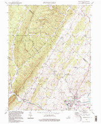
1994 Map of Timberville
USGS Topo · Published 1997About this map
Little North Mountain and the high ridges of the George Washington National Forest dominate the western portion of this mid-1990s survey, illustrating the stark transition from forested slopes to the agricultural valley floor. The North Fork Shenandoah River winds through the southern landscape, serving as a focal point for settlement and early industry near the town of Timberville. This era of the valley is defined by its rural crossroads and traditional community hubs, including Moores Store, Costes Store, and Getz Corner. Local genealogy and social history are well-represented through numerous community landmarks such as St Johns Ch, Mt Olivet Ch, and Calvary Ch. The map also captures the industrial footprint of the region, noting features like a Quarry, Mine, and several sewage disposal ponds, reflecting the modernization of local infrastructure alongside historic mountain gaps like Brocks Gap.
Find a feature on this map
60 named features on this map. Tap any name to fly to it.
Don’t see what you’re looking for? This feature index may not catch every label — zoom into the map to look around manually.
Map Details
Editions of this 1994 Timberville Map
This is the sole edition of this map. No revisions or reprints were ever made.
Other maps of this area

1892 · Woodstock
USGS Topo · 1:125,000

1921 · Orkney Springs
USGS Topo · 1:48,000

1923 · Orkney Springs
USGS Topo · 1:62,500

1923 · Edinburg
USGS Topo · 1:62,500

1940 · Orkney Springs
USGS Topo · 1:48,000

1942 · Mt Jackson
USGS Topo · 1:62,500

1943 · Orkney Springs
USGS Topo · 1:62,500

1944 · Orkney Springs
USGS Topo · 1:62,500

1946 · Mt Jackson
USGS Topo · 1:62,500

1947 · Mt Jackson
USGS Topo · 1:62,500