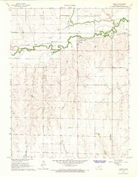
1966 Map of Timken
USGS Topo · Published 1967About this map
Walnut Creek and the Atchison Topeka and Santa Fe railroad corridor anchor this mid-1960s survey of central Rush County. The small community of Timken sits at the center of a rural landscape organized into townships including Lone Star, Pioneer, Banner, and Garfield. This era reveals an economy balanced between traditional agriculture and growing industrial activity, evidenced by the numerous Oil Wells concentrated in the northeast and several sandpits scattered across the terrain. Cultural sites for genealogical study are prominent, including the Holy Cross Cem and the Bohemian Cem, while a small Landing Field near the creek highlights the local aviation infrastructure of the time. The transition from the alluvial bottomlands of Dry Walnut Creek to the surrounding uplands is clearly delineated by the detailed topography of the mid-century period.
Find a feature on this map
18 named features on this map. Tap any name to fly to it.
Don’t see what you’re looking for? This feature index may not catch every label — zoom into the map to look around manually.
Map Details
Editions of this 1966 Timken Map
This is the sole edition of this map. No revisions or reprints were ever made.
Other maps of this area

1889 · Larned
USGS Topo · 1:125,000

1891 · Larned
USGS Topo · 1:125,000

1896 · Hays
USGS Topo · 1:125,000

1955 · Great Bend
USGS Topo · 1:250,000

1957 · Great Bend
USGS Topo · 1:250,000

1958 · Great Bend
USGS Topo · 1:250,000
1965 · Otis
USGS Topo · 1:24,000
1965 · Albert
USGS Topo · 1:24,000

1966 · Rush Center
USGS Topo · 1:24,000

1966 · La Crosse
USGS Topo · 1:24,000