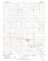
1965 Map of Otis
USGS Topo · Published 1967About this map
Industrial activity and agricultural town sites define this mid-1960s survey of central Kansas. Otis sits at the intersection of the Missouri Pacific railroad and local transport routes, serving as a hub for both the surrounding prairie and specialized energy infrastructure. The presence of a large refinery and the Bureau of Mines Helium Plant south of town underscores the region's importance to the national helium supply and petroleum economy during the Cold War era.
Find a feature on this map
15 named features on this map. Tap any name to fly to it.
Don’t see what you’re looking for? This feature index may not catch every label — zoom into the map to look around manually.
Map Details
Editions of this 1965 Otis Map
This is the sole edition of this map. No revisions or reprints were ever made.
Other maps of this area

1889 · Larned
USGS Topo · 1:125,000

1891 · Great Bend
USGS Topo · 1:125,000

1891 · Larned
USGS Topo · 1:125,000

1893 · Great Bend
USGS Topo · 1:125,000

1896 · Russell
USGS Topo · 1:125,000

1896 · Hays
USGS Topo · 1:125,000

1955 · Great Bend
USGS Topo · 1:250,000

1957 · Great Bend
USGS Topo · 1:250,000

1958 · Great Bend
USGS Topo · 1:250,000
1960 · Heizer
USGS Topo · 1:24,000