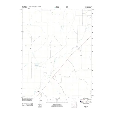
2011 Map of Timpas
USGS Topo · Published 2011About this map
The settlement of Timpas stands at a central junction on this 2011 survey, reflecting the enduring arid-land infrastructure of Otero County. Located southeast of the village, the Timpas Cemetery provides a significant touchstone for genealogical research in this sparsely populated region. The landscape is defined by its drainage systems, with the intermittent flows of Timpas Creek, South Dry Creek, and West Dry Creek cutting through the terrain. The presence of Brown Reservoir and several named arroyos, including Lone Tree Arroyo and Hoe Ranch Arroyo, illustrates the essential relationship between local water management and ranching operations. Further south along the primary transportation corridor lies the location of Ayer, which, along with various rural routes like Aguirre Rd, indicates the historical movement and settlement patterns established long before modern mapping.
Find a feature on this map
16 named features on this map. Tap any name to fly to it.
Don’t see what you’re looking for? This feature index may not catch every label — zoom into the map to look around manually.
Map Details
Editions of this 2011 Timpas Map
This is the sole edition of this map. No revisions or reprints were ever made.
Other maps of this area

1891 · Timpas
USGS Topo · 1:125,000

1894 · Timpas
USGS Topo · 1:125,000

1955 · La Junta
USGS Topo · 1:250,000

1958 · La Junta
USGS Topo · 1:250,000

1965 · La Junta SW
USGS Topo · 1:24,000
1966 · Hawley
USGS Topo · 1:24,000

1968 · La Junta
USGS Topo · 1:250,000
1972 · Timpas NE
USGS Topo · 1:24,000

1972 · Packers Gap
USGS Topo · 1:24,000
1972 · Timpas SW
USGS Topo · 1:24,000